From Onpyeong to Pyoseon, Walk the Coastal Side of Olle Route 3-B
the other path on Olle Route 3, tracing the coast
Jeju Olle Route 3 is said to run from Onpyeong Port to Pyoseon Beach, but even though the start and end points are the same, the route is said to split into two paths along the way. One is Route 3-A, said to cut through the mid-mountain area, and the one GYULI wants to break down today is the other path, Route 3-B, which is said to follow the coastline. Both routes are said to start at Onpyeong and finish at Pyoseon, but reviews often say the scenery along the way is quite different between the two. If the mid-mountain route keeps forest, fields, and oreum close by, Route 3-B is often introduced as a coastal path that keeps the sea in view from start to finish. Having two such different paths share the same starting and ending points feels like one of the fun parts of the Olle Trail. Today, GYULI will focus on Route 3-B, the one that follows the coast.
From Onpyeong to Pyoseon, a path that keeps the sea close by
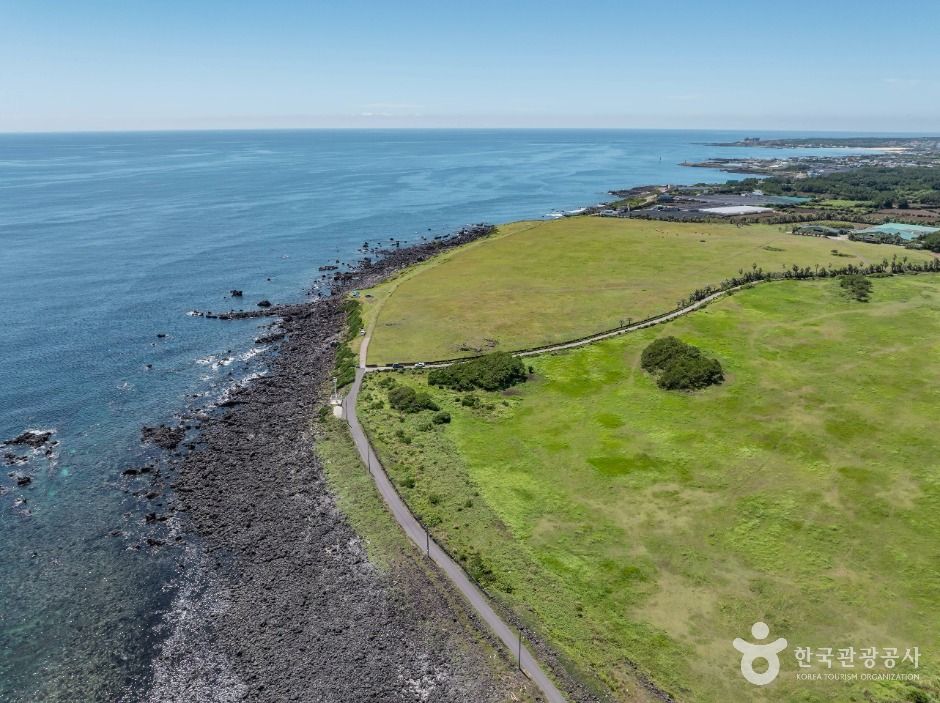
Route 3-B is said to start at Onpyeong Port and follow the coastline before finishing at Pyoseon Beach. Once you leave the village and step onto the shore, low breakwaters, rocky tidal flats, and a wide-open horizon are said to keep unfolding one after another. Unlike the mid-mountain route, there's said to be little climbing up and down oreum, and instead a flat coastal road and seaside walkway are said to stretch on for a long stretch, so reviews describe the walking rhythm as fairly steady. The route is often introduced as passing through Sinsan-ri, Samdal-ri, Sinpung-ri, and Sincheon-ri, with each village said to offer a slightly different view of the sea. In some stretches, wide rocky tidal flats are said to appear, and in others, a pavilion is said to give you a spot to sit and take in the sea for a moment, though the exact locations and order seem to be described a little differently depending on the source and season, so I'll treat this as a reference rather than something settled. As you get closer to Pyoseon, the sandy beach is said to gradually widen, so you can picture it as a walk that keeps the sea in view the whole way before finishing at a wide stretch of beach.
A path that keeps the sea close, different from Route 3-A
Route 3-A, which runs through the mid-mountain area, and Route 3-B both start at the same Onpyeong and finish at the same Pyoseon, but the scenery along the way is said to be quite different. If Route 3-A is a path that shows the inland side of Jeju through forest trails, fields, and oreum, Route 3-B is said to keep the sea close from start to finish, so you get to hear the waves and feel the sea breeze for much longer. On the other hand, the coastal road is said to have very little shade, so it's worth keeping in mind that you'll be exposed to the sun for a long stretch in summer. On windy days, the coastal section is said to feel the wind more strongly, so bringing a hat with a strap so it doesn't blow away, or packing a windbreaker, is said to help. On the flip side, on overcast or cool days, the wide-open sea view is said to make it an especially pleasant course to walk. Rather than saying one route is better than the other, it's worth picking Route 3-A if you like forests and oreum, or Route 3-B if you prefer the sea and open views.
From Onpyeong to Pyoseon, even with the same starting and ending points, there are said to be two paths — Route 3-A through the forest, and Route 3-B along the sea.
— 🍊 GYULIWhat's worth bringing for the coastal walk
Since it's a coastal route, facilities like restrooms and convenience stores are said to be relatively easy to find near Onpyeong Port or around Pyoseon, but they're said to be sparse through the village stretches in between, so it's safer to pack water and snacks ahead of time. The Olle Trail's signature ribbons and arrow markers are said to continue closely along the coastal section too, but reviews say the markers can be harder to spot around breakwaters or rocky tidal flats, so it's safer to pause and check for markers at forks in the path. Wet rocky areas are said to get slippery, so shoes with good grip are worth wearing. The exact total distance and time to finish are again said to be described a little differently depending on the source, so I'll be careful not to state it too confidently, but since it's mostly coastal road rather than oreum climbs, it's often said to be less physically demanding. That said, since it's a route with long exposure to wind and sun, it's worth taking your time and resting along the way.
GYULI's Tip · The exact total distance, time, and detailed path of Olle Route 3-B are said to be described a bit differently depending on the source, so be sure to check the latest information and course map before you go. The coastal road has little shade, so bring plenty of water, a hat, and sunscreen in summer, and wear shoes with good grip for the rocky tidal-flat sections.